Tidewalk
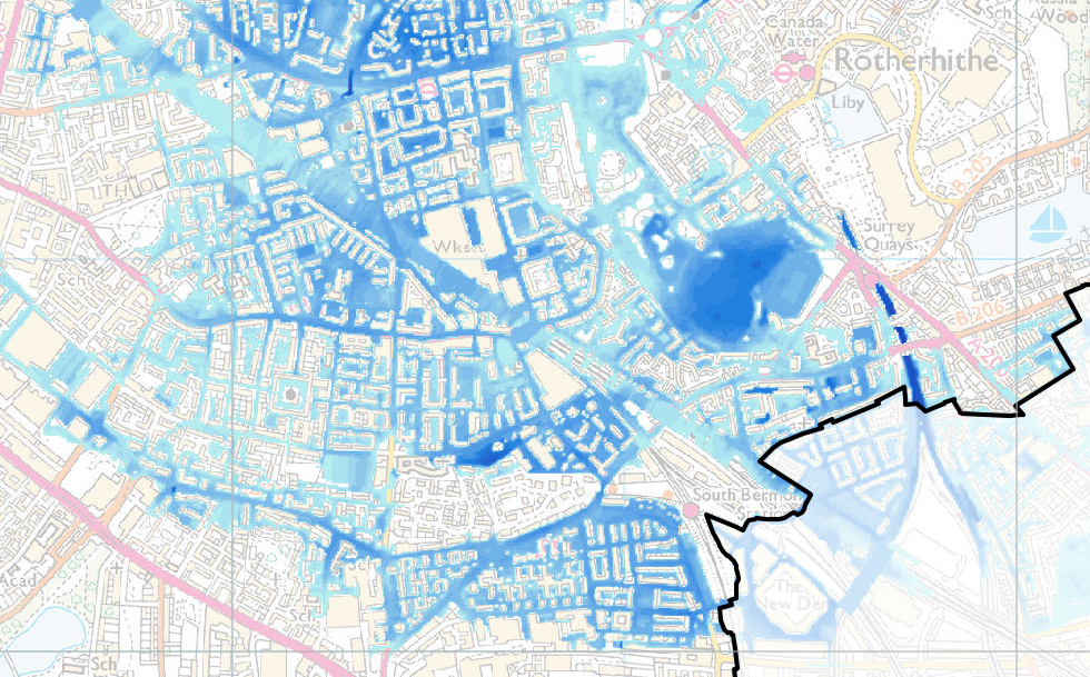
Sea level rise scenarios combined with river flooding could see large parts of Central London under water in the future, even with the current Thames barrier in place. Based on the current science, large low-lying parts of Westminster, Southwark and Lambeth could be inundated creating temporary islands and peninsulas separated by shallow running reaches of water.
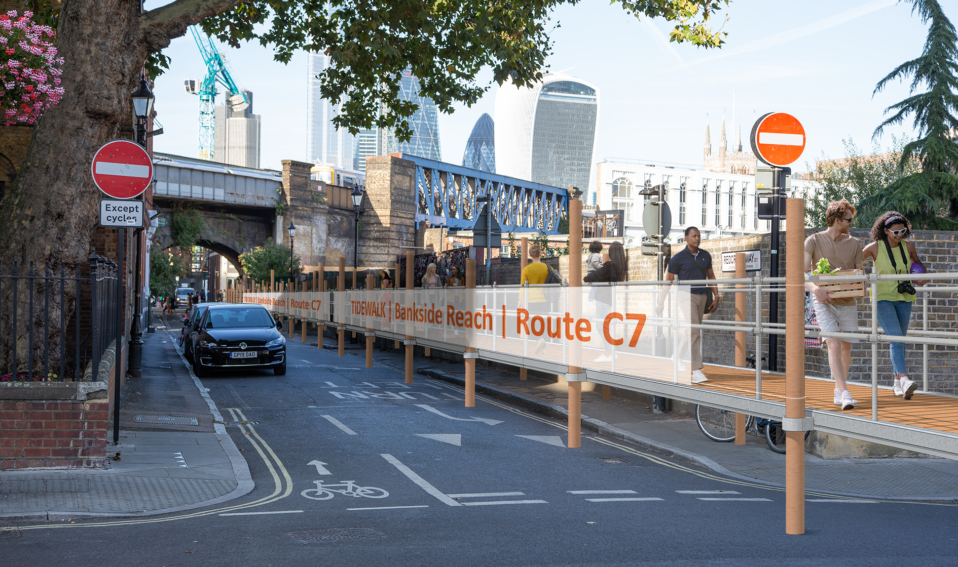
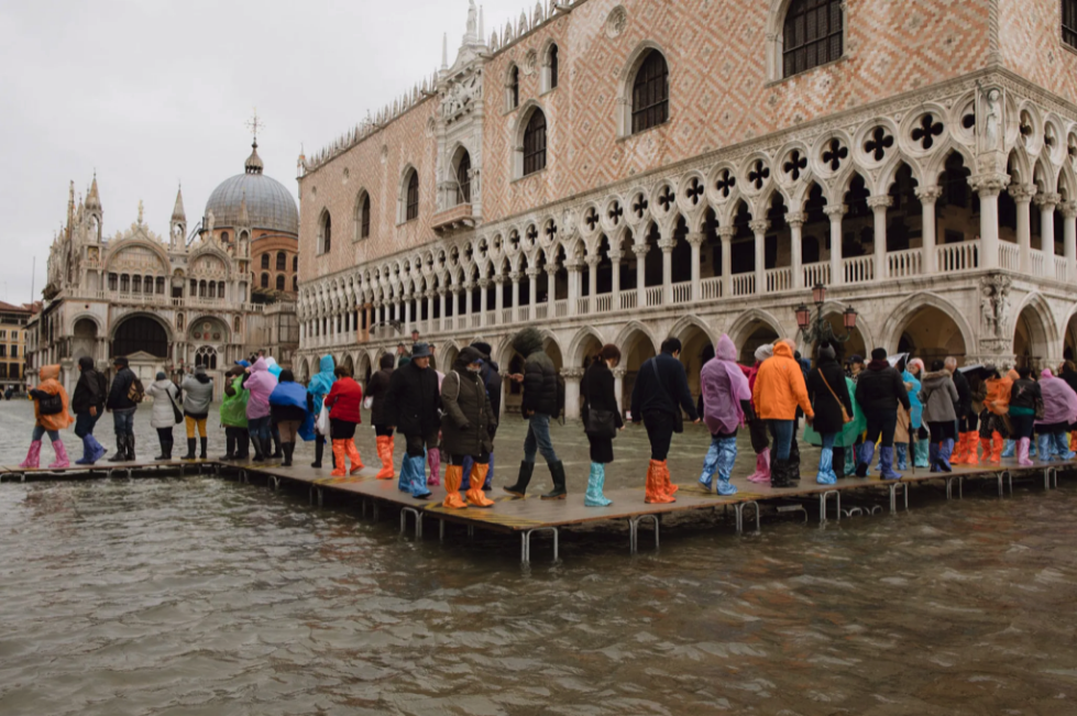
Tidewalk will be an emergency structure from that possible future, physically installed in the present-day city. The proposal is for sections of temporary raised walkways to be built to cross the stretches of water that would exist if these projected sea level scenarios were to occur, allowing people to continue to move about the flooded city on foot.
This art project will create unexpected encounters with the type of structures ordinarily associated with watery environments, amidst the everyday bustle of busy streets and public spaces. This incongruous juxtaposition aims to provoke thought and conversation around sea level rise and wider the climate crisis.
As well as acting as ‘provocations’, the structures will also be participatory artworks that people can walk along and interact with. The aim is to take abstract, scientific data (sea level projections) and convert that in to an embodied experience by physically lifting participants up to a new (formerly abstract) level and literally changing their perspective. By doing this, the project invites the audience to recreate in their imagination the flooded streets below the walkways they are traversing.
Both now and in the future
As a future infrastructure project, Tidewalk would form an extensive network of walkways linking important parts of the city and joining up communities cut off by the flood waters. Local ferries would also stop at jetties connected to the walkways, allowing people to make longer journeys across wider, deeper stretches of water.
As a present-day artwork, foreshadowing that future, Tidewalk will comprise smaller sections of walkway placed ‘as if’ they were part of that bigger future network.
The location and height of each section will be based on current projected sea level scenarios for 2100, and use up to date flood risk mapping. (This mapping takes account of sea level rise, weather conditions and potential breaches of the Thames embankments).
Both art object and functional infrastructure
As a matter of practicality and affordability, Tidewalk will be easily put together and quickly demountable, using inexpensive, easily sourced materials. The structures will also be safe to use in the public realm and comply with relevant regulations. This essentially means that Tidewalk will also become a piece of fully functional infrastructure that could actually be used in real flood situations.
Capitalising on this, Tidewalk will be developed simultaneously as an art project and as a usable disaster relief solution. Designs and assembly instructions would be shared with communities, local authorities and relevant agencies who deal with flooding. This could be deployed, for example, during the increasingly frequent river flood events.
This dual use as art-object and utilitarian object (depending on the context in which it is placed) conceptually reflects the fact that the effects of climate change are simultaneously a present-day reality and (on a larger scale) a projected future.
Both art provocation and functional infrastructure
One or more wider landing stages/jetties would be incorporated that would also act as gathering spaces.
Tidewalk might also become a platform or forum for other artists’ interventions, music, food, events, talks etc.
The jetties that form part of Tidewalk might be experienced as ‘points of departure’ literally (in the imagined future where boats arrive and depart in this flooded landscape) and metaphorically, prompting and providing a forum for ongoing discussion.
Tidewalk ‘products’
- A tube/metro style map showing the completed network of raised walkways and jetties as they might be in 2100. This would use current strategic flood risk mapping and other mapping data to inform the routes.
. - Based on this mapping, small stretches of the Tidewalk network will be physically created in real space, including one or more jetties. These real-life walkways will exist ‘as if’ they were fragments of the future network right at the beginning of construction.
. - Working with other artists /cultural organisations, Tidewalk route will become elevated viewing platforms, leading audience along an ‘art trail’ with street art on walls, building projections, sculpture and ‘happenings’ of all kinds experienced along the route. These works would broadly address the climate crisis. The ‘jetties’ would also, at times, become stages hosting talks, live music and other events.
. - Tidewalk may result in the temporary closure of minor roads to cars, while it runs, creating temporary public spaces, play streets etc. negotiated with the relevant local authorities. This could potentially link in with longer term ‘Low Traffic Neigbourhoods’ strategies.
. - Tidewalk will also become a practical piece of infrastructure that can be deployed during real floods. The design process will result in an easily replicable structure that uses inexpensive, repurposable materials which can be easily sourced local to the flood event. This will be freely shared with local authorities, communities etc.